How can I change the Type on a GIS route from fligth path to Driving Roads using Code?
How to change a GIS route Type with Code
FlexSim 22.2.4
Hi @Julio R, was Felix Möhlmann's answer helpful? If so, please click the "Accept" button at the bottom of their answer. Or if you still have questions, add a comment and we'll continue the conversation.
If we haven't heard back from you within 3 business days we'll auto-accept an answer, but you can always unaccept and comment back to reopen your question.
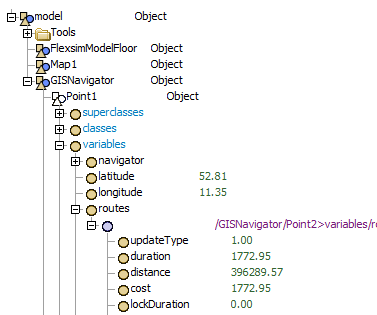
The path nodes can be found in the GIS points' attribute tree, in the "variables" node. To change the route type, adjuste the value of the "updateType" node and refresh the connection.
treenode navigator = Model.find("GISNavigator");
treenode object = navigator.find("Point1>variables/routes/1");
if (object)
{
    object.subnodes["updateType"].value = GIS_UPDATE_TYPE_DRIVING_ROADS;

    function_s(navigator, "updateRoute", object);

    function_s(navigator, "setMapsDirty", GIS_DIRTY_ROUTES);
    repaintall();
}
Apart from setting the node value, the code is taken from the OnPress event of the refresh button in the GIS path GUI.

14 People are following this question.