question

Filippo C5 avatar image
1 Like"
Filippo C5 asked Clair A commented

How to set a travel duration that follows a probability distribution with GIS?

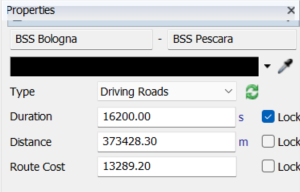
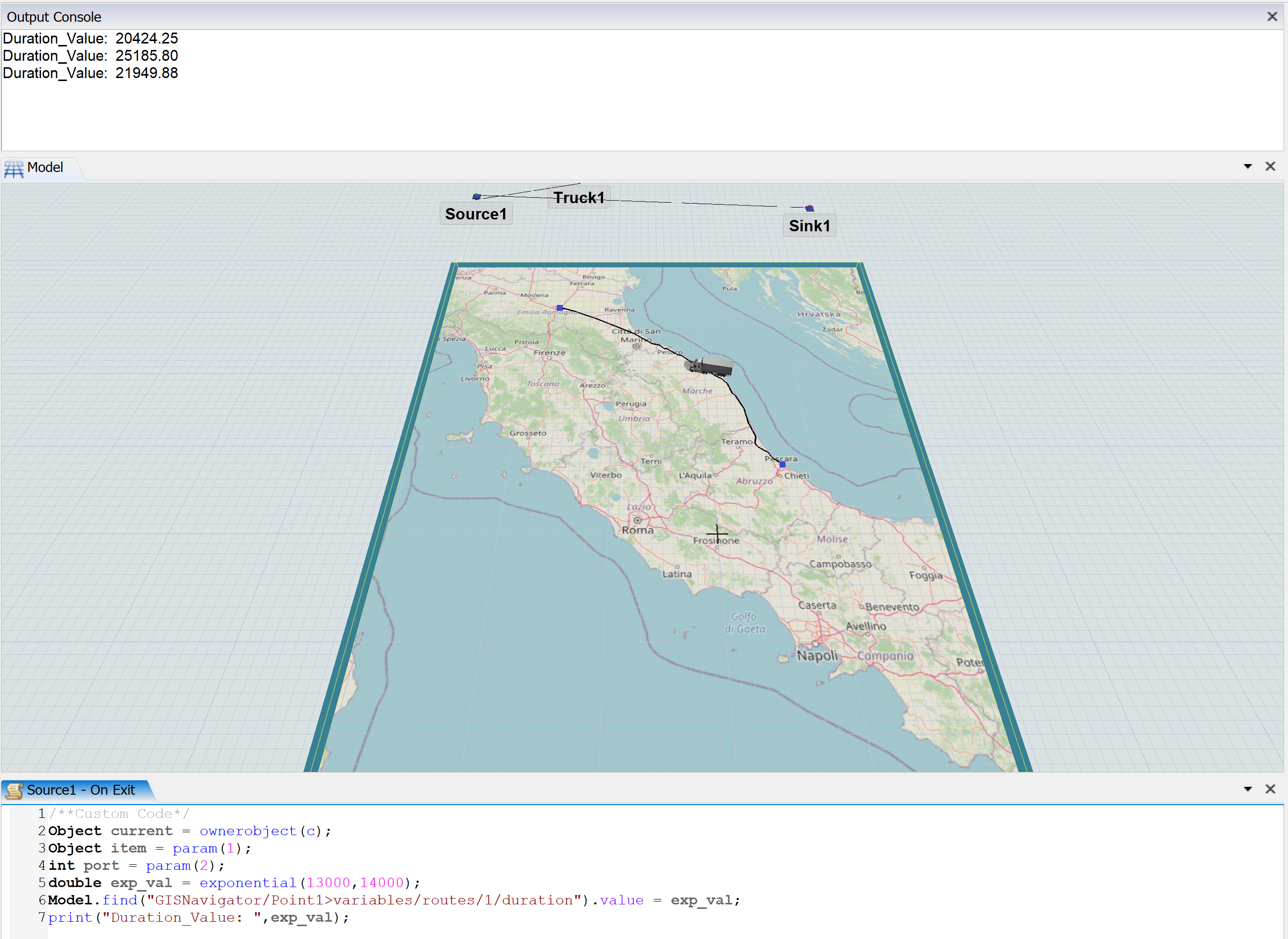
I am modeling some transport routes using GIS Navigator and I would need the trucks to take a variable time (according to a probability distribution) to complete the journey.

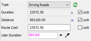
In the route settings I can only set the duration of the trip or the speed of the task executer .

1645006632815.png

FlexSim 22.0.0
transportgisgis navigatortravel durationjourney duration
1645006632815.png (21.7 KiB)
· 1
5 |100000

Up to 12 attachments (including images) can be used with a maximum of 23.8 MiB each and 47.7 MiB total.

Ryan Clark avatar image Ryan Clark commented ·

Hi @Filippo C5, was one of Phil BoBo's or Sara Bonansea's answers helpful? If so, please click the "Accept" button at the bottom of the one that best answers your question. Or if you still have questions, add a comment and we'll continue the conversation.

If we haven't heard back from you within 3 business days we'll auto-accept an answer, but you can always unaccept and comment back to reopen your question.

0 Likes 0 ·
Sara Bonansea avatar image
0 Likes"
Sara Bonansea answered Jason Lightfoot commented

Hi Filippo,

a possible solution can be to set the duration before the transport task starts. For example, in the model attached, I modify the duration value accessing the corresponding treenode using the on exit trigger on the source. model-test-gis.png

Otherwise, you can write a ProcessFlow for each mission where you increase the mission time using a delay calculated with a probability distribution.

Which is your opinion @Phil BoBo?


TestModel_GIS.fsm


model-test-gis.png (1.2 MiB)
testmodel-gis.fsm (152.1 KiB)
· 2
5 |100000

Up to 12 attachments (including images) can be used with a maximum of 23.8 MiB each and 47.7 MiB total.

Filippo C5 avatar image Filippo C5 commented ·

Thank you so much for the answer.

This is very interesting. But if there are many trucks traveling on the same route and at the same time the duration will change for every truck or this method will not work properly? Beacuse I need to model a logistic service, with many trucks traveling at the same time, but strating their travel at different times.


Unfortunaely the second option you suggest is not possible, because there are many many missions.

0 Likes 0 ·
Jason Lightfoot avatar image Jason Lightfoot ♦ Filippo C5 commented ·

You would construct a process flow so that it was generic - maybe each is defined by data structures - not have a process flow for each mission.

0 Likes 0 ·
Phil BoBo avatar image
1 Like"
Phil BoBo answered Clair A commented

The route's duration is not stored per-traveler. If you dynamically change the duration of a route, then it will affect the other travelers that are already on that route. Their totaltraveldist statistics will not be calculated correctly, and they won't be positioned correctly as they travel along the route. Stopping or preempting a traveler mid-route will also not work properly.

Making a route's duration vary by traveler would require significant changes to how the GIS Navigator works.

Sara's suggestion of adding a delay at the end of the travel to account for the variability of durations is probably the best workaround right now. Set the route to the minimum duration of your distribution and then add a delay for the variable range of the distribution.

I'll add a case to the dev list to consider updating the GIS Navigator to be able to handle variable route durations per traveler for a future version.

· 2
5 |100000

Up to 12 attachments (including images) can be used with a maximum of 23.8 MiB each and 47.7 MiB total.

Alessio Merlo avatar image Alessio Merlo commented ·

@ phil, an idea could be to provide to the user a custom field to define the duration.

Something like this:

1645178393614.png

With a custom duration the user is free to return the defined duration value, increases or reduces it with a "traffic" coefficient or anything else.

In my mind the custom duration would receive as input parameters:

  • start point;
  • end point;
  • defined duration and distance;
  • traveller;

In this way I could define dinamically the travel time to simulate traffic or any sort of time variation without any impact on the route choice.

This is an idea. Take it into account for the future GIS module improvements.

0 Likes 0 ·
1645178393614.png (7.1 KiB)
Clair A avatar image Clair A commented ·

Hi @Phil BoBo , you can add my vote to the case "updating the GIS Navigator to be able to handle variable route durations per traveler for a future version."

One of our users wants to simulate a public transport network by bus. The travel times between bus stops are defined by statistical distributions. Most of the times there is only one bus travelling between 2 bus stops, so updating the route duration just before the travel task starts could work. But sometimes there are also several buses on the same route, with their own travel times since they are defined with statistical distributions.

0 Likes 0 ·

Write an Answer

Hint: Notify or tag a user in this post by typing @username.

Up to 12 attachments (including images) can be used with a maximum of 23.8 MiB each and 47.7 MiB total.