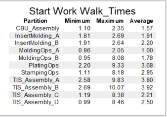
I am using the People Module to model many employees walking within a large plant. We need to find out how to measure congestion and compare layouts. I can get statistics on their walk-times using zones with partitions for their work locations (which is a label). That works very nicely.

But how do I find a way to measure congestion?
I would like to be able to show % Blocked when walking, but there does not seem to be a way to easily get the State of a Person. And the internal data from the AStar navigation is not available, so I can't get a numerical idea of what the heat map means in comparative terms.
Maybe I could use a calculated table to get a measure of how much the average walk time differs from the minimum, in % terms?
Any other ideas?
