question

Tomi Kosunen avatar image
0 Likes"
Tomi Kosunen asked Logan Gold commented

GIS Server

Hi

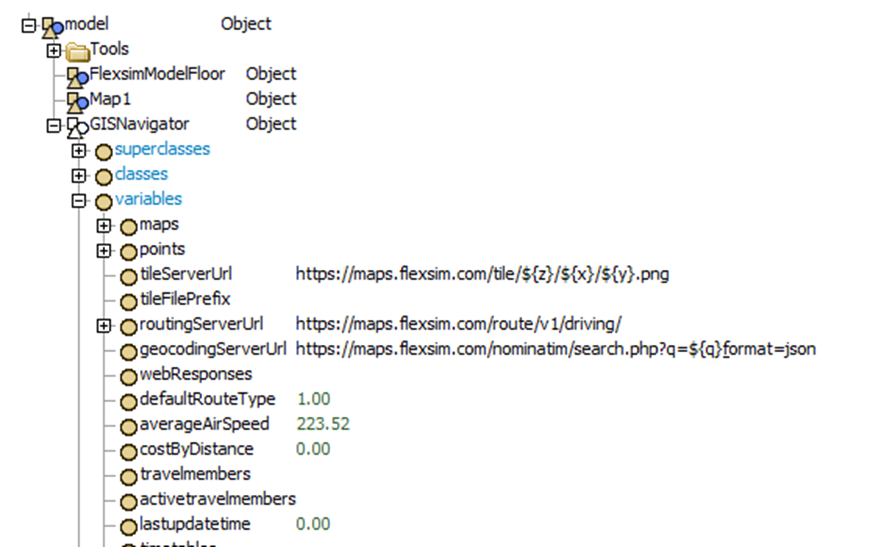
Does anyone in this forum has experience about hosting own GIS server or using paid service (Open Source Routing Machine, GEOFABRIK, or Fast Routing API)?

Any advice, if paid service can be easily connected or does it require configuration?


1679300850159.png

See also: https://answers.flexsim.com/questions/128316/gis-module-calculate-route-driving-roads-type-does.html


FlexSim 23.0.1
gis
1679300850159.png (174.3 KiB)
· 1
5 |100000

Up to 12 attachments (including images) can be used with a maximum of 23.8 MiB each and 47.7 MiB total.

Jeanette F avatar image Jeanette F ♦♦ commented ·

Hi @Tomi Kosunen, was Logan Gold's answer helpful? If so, please click the "Accept" button at the bottom of their answer. Or if you still have questions, add a comment and we'll continue the conversation.

If we haven't heard back from you within 3 business days we'll auto-accept an answer, but you can always unaccept and comment back to reopen your question.

0 Likes 0 ·

1 Answer

·
Logan Gold avatar image
0 Likes"
Logan Gold answered Logan Gold commented

Hey @Tomi Kosunen, we wanted to see if anybody in the community could answer with any specific experiences they've had with using a GIS server other than the default. Since nobody has answered, I at least wanted to give you some general information in case you still wanted to pursue it.

As far as configuration goes, you don't need to do anything specific when configuring a GIS tile or routing server to work with FlexSim. I can't really comment on what it takes to get a specific service or software up and going, but as long as your preferred service or software is configured according to its own specifications, it should work with FlexSim.

As far as configuring the GIS navigator in FlexSim, you should only need to put the right URL in the properties:

https://docs.flexsim.com/en/23.1/Reference/Tools/GIS/GIS.html#properties

This link to the documentation also has an example of using a custom Routing server. And you can find an example of a custom Tile server in this other post:

https://answers.flexsim.com/questions/126986/how-to-replace-the-gis-map.html

· 2
5 |100000

Up to 12 attachments (including images) can be used with a maximum of 23.8 MiB each and 47.7 MiB total.

Tomi Kosunen avatar image Tomi Kosunen commented ·
@Logan Gold Thanks. We have proceed with the project and the problems are now solved or under testing.


We got a one month test account from Geofabric. And the configuration was, like you wrote, very simple. We just changed the routing server address and that was it.

The result from out tests was that the GIS Server provided by FlexSim is quite good. It didn't make big difference to use Geofabric. It just seems that loading thousands of routes into one FlexSim model is just too hard job. And if you think about it for a while, you may realize that there is quite a lot of data to handle.

So our solution was to update the route in live during the simulation and minimize the pre-loaded routes (as we have too many routes). Now we are considering our own/local osrm server (routing server) installation.

0 Likes 0 ·
Logan Gold avatar image Logan Gold ♦♦ Tomi Kosunen commented ·

Thank you for the feedback. I'm glad you were able to get some things figured out.

0 Likes 0 ·

Write an Answer

Hint: Notify or tag a user in this post by typing @username.

Up to 12 attachments (including images) can be used with a maximum of 23.8 MiB each and 47.7 MiB total.